KevinO.org Weather Page
Current Conditions
Phoenix, Phoenix Sky Harbor International Airport, AZ, United States (KPHX) 33-26-03N 112-03-04W 336M
Jun 05, 2026 - 03:51 AM EDT / 2026.06.05 0751 UTC
Wind: from the W (270 degrees) at 15 MPH (13 KT):0
Visibility: 10 mile(s):0
Sky conditions: clear
Temperature: 91.9 F (33.3 C)
Dew Point: 28.9 F (-1.7 C)
Relative Humidity: 10%
Pressure (altimeter): 29.72 in. Hg (1006 hPa)
ob: KPHX 050751Z 27013KT 10SM CLR 33/M02 A2972 RMK AO2 SLP042 T03331017
cycle: 8
Extended Forecast
Paradise Valley, Mesa, Chandler, Tempe, Gilbert, Sun Lakes,
and Queen Creek
1130 PM MST Thu Jun 4 2026
TONIGHT...Clear. Lows 72 to 80. West wind 5 to 15 mph.
FRIDAY...Sunny. Highs 103 to 108. South wind 5 to 10 mph in the
morning becoming west 5 to 15 mph in the afternoon.
FRIDAY NIGHT...Clear. Lows 72 to 79. West wind 10 to 20 mph in the
evening becoming south 10 to 15 mph after midnight.
SATURDAY...Mostly sunny. Highs 102 to 107. Southeast wind around
5 mph in the morning becoming southwest 10 to 15 mph in the
afternoon.
SATURDAY NIGHT...Partly cloudy. Lows 71 to 79. Southwest wind 10 to
20 mph in the evening becoming northeast 5 to 10 mph after midnight.
SUNDAY...Mostly sunny. Highs 99 to 107.
SUNDAY NIGHT...Clear. Lows 67 to 74.
MONDAY...Sunny. Highs 98 to 106.
MONDAY NIGHT...Clear. Lows 67 to 74.
TUESDAY...Sunny. Highs 100 to 106.
TUESDAY NIGHT...Clear. Lows 68 to 75.
WEDNESDAY...Sunny. Highs 100 to 106.
WEDNESDAY NIGHT...Clear. Lows 69 to 75.
THURSDAY...Sunny. Highs 99 to 105.
Radar Loop

US Radar Summary

Maricopa County Rainfall and Stream Flow Data
maricopa.gov
MIMIC-TPW2

MIMIC-TPW2
Water Vapor Geos West

NOAA GOES-West Geocolor

NOAA GOES West

Visible Satellite GEOS West

Water Vapor Geos East

Visible Satellite GEOS East

NOAA GOES-East Geocolor

NOAA GOES East

Atlantic Tropical

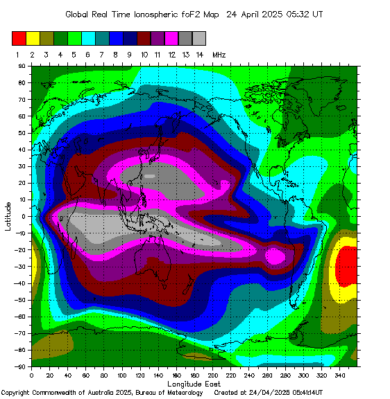
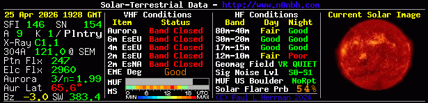
Radio Propagation
Space Weather
webmaster
